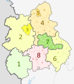
الملف الأصلي (ملف SVG، أبعاده 1٬161 × 1٬306 بكسل، حجم الملف: 1٫38 ميجابايت)
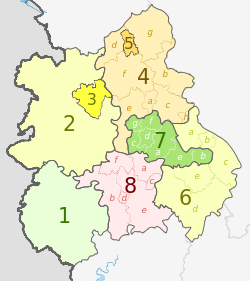
Map
Ceremonial county
Shire county / unitary
Districts
1. Herefordshire U.A.
Shropshire 2. Shropshire U.A.
3. Telford and Wrekin U.A.
Staffordshire 4. Staffordshire †
a ) Cannock Chase , b ) East Staffordshire , c ) Lichfield , d ) Newcastle-under-Lyme , e ) South Staffordshire , f ) Stafford , g ) Staffordshire Moorlands , h ) Tamworth
5. Stoke-on-Trent U.A.
6. Warwickshire †
a ) North Warwickshire , b ) Nuneaton and Bedworth , c ) Rugby , d ) Stratford-on-Avon , e ) Warwick
7. West Midlands *
a ) Birmingham , b ) Coventry , c ) Dudley , d ) Sandwell , e ) Solihull , f ) Walsall , g ) Wolverhampton
8. Worcestershire †
a ) Bromsgrove , b ) Malvern Hills , c ) Redditch , d ) Worcester , e ) Wychavon , f ) Wyre Forest
Key: †shire county | *metropolitan county
نسب العمل لمُؤَلِّفه: Dr Greg and Nilfanion. Contains Ordnance Survey data © Crown copyright and database right 2011
يحقُّ لك:
مشاركة العمل – نسخ العمل وتوزيعه وبثُّهإعادة إنتاج العمل – تعديل العمل
حسب الشروط التالية:
نسب العمل إلى مُؤَلِّفه – يلزم نسب العمل إلى مُؤَلِّفه بشكل مناسب وتوفير رابط للرخصة وتحديد ما إذا أجريت تغييرات. بالإمكان القيام بذلك بأية طريقة معقولة، ولكن ليس بأية طريقة تشير إلى أن المرخِّص يوافقك على الاستعمال.الإلزام بترخيص المُشتقات بالمثل – إذا أعدت إنتاج المواد أو غيرت فيها، فيلزم أن تنشر مساهماتك المُشتقَّة عن الأصل تحت ترخيص الأصل نفسه أو تحت ترخيص مُتوافِقٍ معه. https://creativecommons.org/licenses/by-sa/3.0 CC BY-SA 3.0 Creative Commons Attribution-Share Alike 3.0 true true
This image is a derivative work of the following images:
File:West_Midlands_districts_2011_map.svg licensed with Cc-by-sa-3.0, GFDL
2011-05-01T19:06:46Z Nilfanion 1161x1306 (1392730 Bytes) == Summary == {{Information |Description=Map of the [[w:West Midlands|West Midlands]] region showing the administrative districts. Equirectangular map projection on WGS 84 datum, with N/S stretched 165% Geographic limits: * File:English_ceremonial_counties_2010.svg licensed with Cc-by-sa-3.0, GFDL
2010-11-23T16:39:55Z Nilfanion 1108x1345 (308868 Bytes) thicker lines
2010-11-23T16:20:19Z Nilfanion 1108x1345 (301520 Bytes) tweaks
2010-10-26T20:34:20Z Nilfanion 817x990 (1391832 Bytes) {{Information |Description=Map showing the [[w:ceremonial counties of England]] including the City of London, in 2010. Equirectangular map projection on WGS 84 datum, with N/S stretched 170% Geographic limits: *West: 6.75W Uploaded with derivativeFX
العربية أضف شرحاً من سطر واحد لما يُمثِّله هذا الملف
تاريخ الملف
اضغط على زمن/تاريخ لرؤية الملف كما بدا في هذا الزمن.
زمن/تاريخ صورة مصغرة الأبعاد مستخدم تعليق حالي 20:01، 5 مايو 2012 1٬161 × 1٬306 (1٫38 ميجابايت) Dr Greg lighten black boundary line 21:19، 2 مايو 2012 1٬161 × 1٬306 (1٫38 ميجابايت) Dr Greg == {{int:filedesc}} == {{Information |Description={{en|Map of the West Midlands region of England, showing its counties and administrative districts. The county colours are the same as those in [[:File:English metropolitan ...
استخدام الملف
الصفحة التالية تستخدم هذا الملف:
الاستخدام العالمي للملف
الويكيات الأخرى التالية تستخدم هذا الملف:
الاستخدام في bar.wikipedia.org
الاستخدام في de.wikipedia.org
الاستخدام في en.wikipedia.org
الاستخدام في fa.wikipedia.org
الاستخدام في frr.wikipedia.org
الاستخدام في fr.wikipedia.org
الاستخدام في hr.wikipedia.org
الاستخدام في hu.wikipedia.org
الاستخدام في lv.wikipedia.org
الاستخدام في mr.wikipedia.org
الاستخدام في pl.wikipedia.org
الاستخدام في pnb.wikipedia.org
الاستخدام في pt.wikipedia.org
الاستخدام في th.wikipedia.org
الاستخدام في tr.wikipedia.org
الاستخدام في ur.wikipedia.org
الاستخدام في vec.wikipedia.org
الاستخدام في vi.wikipedia.org
الاستخدام في vls.wikipedia.org
الاستخدام في zh-yue.wikipedia.org


