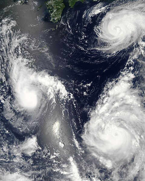
ملف:Maria, Bopha and Saomai 2006-08-07 0435Z.jpg

حجم هذه المعاينة: 480 × 600 بكسل. الأبعاد الأخرى: 192 × 240 بكسل | 384 × 480 بكسل | 614 × 768 بكسل | 819 × 1٬024 بكسل | 1٬638 × 2٬048 بكسل | 7٬200 × 9٬000 بكسل.
الملف الأصلي (7٬200 × 9٬000 بكسل حجم الملف: 7٫6 ميجابايت، نوع MIME: image/jpeg)
تاريخ الملف
اضغط على زمن/تاريخ لرؤية الملف كما بدا في هذا الزمن.
| زمن/تاريخ | صورة مصغرة | الأبعاد | مستخدم | تعليق | |
|---|---|---|---|---|---|
| حالي | 03:06، 8 أغسطس 2006 |  | 7٬200 × 9٬000 (7٫6 ميجابايت) | Good kitty | == Summary == {{Information |Description=Three different typhoons were spinning over the western Pacific Ocean on August 7, 2006, when the Moderate Resolution Imaging Spectroradiometer (MODIS) on NASA’s Aqua satellite acquired this image. The strongest |
استخدام الملف
الصفحة التالية تستخدم هذا الملف:
الاستخدام العالمي للملف
الويكيات الأخرى التالية تستخدم هذا الملف:
- الاستخدام في az.wikipedia.org
- الاستخدام في bg.wikipedia.org
- الاستخدام في bh.wikipedia.org
- الاستخدام في crh.wikipedia.org
- الاستخدام في cs.wikipedia.org
- الاستخدام في de.wikipedia.org
- الاستخدام في en.wikipedia.org
- Typhoon
- Typhoon Saomai
- Tropical cyclone
- Wikipedia:Picture peer review/Archives/Archive2006
- User:Plasticup/MyFavorites
- Typhoon Maria (2006)
- User talk:Hurricanehink/Archive 23
- User talk:Thegreatdr/2012archive
- Wikipedia:Wikipedia Signpost/2013-11-20/Traffic report
- Wikipedia:Wikipedia Signpost/Single/2013-11-20
- Wikipedia:Top 25 Report/November 10 to 16, 2013
- User:Tfmbty/2006 Pacific typhoon season
- User:SongdaTalas/Archives of Former Articles
- الاستخدام في en.wiktionary.org
- الاستخدام في es.wikipedia.org
- الاستخدام في fi.wikipedia.org
- الاستخدام في hi.wikipedia.org
- الاستخدام في id.wiktionary.org
- الاستخدام في incubator.wikimedia.org
- الاستخدام في ja.wikipedia.org
- الاستخدام في ja.wikibooks.org
- الاستخدام في ko.wikipedia.org
- الاستخدام في lo.wikipedia.org
- الاستخدام في ms.wikipedia.org
- الاستخدام في my.wikipedia.org
- الاستخدام في nn.wikipedia.org
- الاستخدام في no.wikipedia.org
- الاستخدام في pt.wikipedia.org
- الاستخدام في ro.wikipedia.org
- الاستخدام في ru.wikipedia.org
- الاستخدام في szy.wikipedia.org
- الاستخدام في th.wikipedia.org
- الاستخدام في tk.wikipedia.org
- الاستخدام في tr.wikipedia.org
- الاستخدام في tt.wikipedia.org
اعرض المزيد من الاستخدام العام لهذا الملف.


