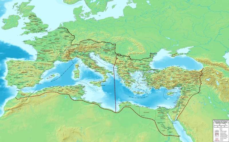
ملف:The Roman Empire ca 400 AD.png

حجم هذه المعاينة: 800 × 496 بكسل. الأبعاد الأخرى: 320 × 198 بكسل | 640 × 397 بكسل | 1٬024 × 635 بكسل | 1٬280 × 793 بكسل | 2٬560 × 1٬587 بكسل | 4٬339 × 2٬689 بكسل.
الملف الأصلي (4٬339 × 2٬689 بكسل حجم الملف: 12٫8 ميجابايت، نوع MIME: image/png)
تاريخ الملف
اضغط على زمن/تاريخ لرؤية الملف كما بدا في هذا الزمن.
| زمن/تاريخ | صورة مصغرة | الأبعاد | مستخدم | تعليق | |
|---|---|---|---|---|---|
| حالي | 22:27، 19 فبراير 2015 |  | 4٬339 × 2٬689 (12٫8 ميجابايت) | Cplakidas | added potential location of Valentia beyond Hadrian's Wall, removed provincial boundaries in Britannia as too tentative |
| 13:03، 21 يوليو 2011 |  | 4٬339 × 2٬689 (10٫9 ميجابايت) | Cplakidas | fixed Persian border, differentiated between Eastern and Western empire, different borders for praet. prefectures | |
| 02:37، 21 مارس 2009 |  | 4٬475 × 2٬600 (9٫99 ميجابايت) | Cplakidas | minor corrections | |
| 12:30، 29 مايو 2008 |  | 3٬800 × 2٬370 (8٫1 ميجابايت) | Cplakidas | ||
| 12:17، 29 مايو 2008 |  | 4٬560 × 2٬850 (11٫22 ميجابايت) | Cplakidas | clearer version & addition of the Armenian satrapies | |
| 02:02، 30 ديسمبر 2007 |  | 3٬380 × 2٬120 (5٫96 ميجابايت) | Cplakidas | added names of dioceses, legend box, various minor adjustments | |
| 14:27، 13 ديسمبر 2007 |  | 3٬550 × 2٬200 (6٫65 ميجابايت) | Cplakidas | new improved version made with Inkscape, slight corrections in borders, added several cities in Africa & Spain | |
| 19:27، 12 نوفمبر 2007 |  | 3٬550 × 2٬200 (4٫75 ميجابايت) | Cplakidas | minor corrections in southern Gaul | |
| 12:58، 5 نوفمبر 2007 |  | 3٬550 × 2٬200 (4٫75 ميجابايت) | Cplakidas | New version, with some corrections & additions | |
| 16:55، 31 أكتوبر 2007 |  | 3٬436 × 2٬142 (4٫5 ميجابايت) | Cplakidas | {{Information |Description=Map of the Roman Empire ca. 400 AD, showing the administrative division into dioceses and provinces, as well as the major cities. The demarcation between Eastern and Western Empires is noted in red. |Source=Base map found at |
استخدام الملف
الصفحتان التاليتان تستخدمان هذا الملف:
الاستخدام العالمي للملف
الويكيات الأخرى التالية تستخدم هذا الملف:
- الاستخدام في af.wikipedia.org
- الاستخدام في ary.wikipedia.org
- الاستخدام في ast.wikipedia.org
- الاستخدام في bg.wikipedia.org
- الاستخدام في bn.wikipedia.org
- الاستخدام في ca.wikipedia.org
- الاستخدام في ceb.wikipedia.org
- الاستخدام في cs.wikipedia.org
- الاستخدام في de.wikipedia.org
- الاستخدام في el.wikipedia.org
- الاستخدام في en.wikipedia.org
- الاستخدام في eo.wikipedia.org
- الاستخدام في es.wikipedia.org
- الاستخدام في et.wikipedia.org
- الاستخدام في fr.wikipedia.org
- الاستخدام في he.wikipedia.org
- الاستخدام في hi.wikipedia.org
- الاستخدام في hr.wikipedia.org
- الاستخدام في hu.wikipedia.org
- الاستخدام في id.wikipedia.org
- الاستخدام في it.wikipedia.org
- الاستخدام في ko.wikipedia.org
- الاستخدام في la.wikipedia.org
اعرض المزيد من الاستخدام العام لهذا الملف.


