ملف:Sunda strait map v4.png
لا توجد دقة أعلى متوفرة.
Sunda_strait_map_v4.png (487 × 351 بكسل حجم الملف: 176 كيلوبايت، نوع MIME: image/png)
| هذا ملف من ويكيميديا كومنز. معلومات من صفحة وصفه مبينة في الأسفل. كومنز مستودع ملفات ميديا ذو رخصة حرة. |
ملخص
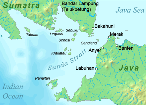
| الوصف |
Deutsch: Karte der Sundastraße, Indonesien
English: Map of the Sunda Strait, Indonesia |
||||
| التاريخ | |||||
| المصدر | عمل شخصي | ||||
| المؤلف | Telim tor | ||||
| الترخيص (إعادة استخدام هذا الملف) |
|
||||
| إصدارات أخرى |

تاريخ الملف
اضغط على زمن/تاريخ لرؤية الملف كما بدا في هذا الزمن.
| زمن/تاريخ | صورة مصغرة | الأبعاد | مستخدم | تعليق | |
|---|---|---|---|---|---|
| حالي | 11:37، 23 يناير 2011 | | 487 × 351 (176 كيلوبايت) | Telim tor | == {{int:filedesc}} == {{Information |Description={{en|Map of the Sunda Strait, Indonesia}} |Source={{own}} |Date=2011-01-23 |Author=Telim tor |Permission={{PD-Demis}} |other_versions=={{Extracted from|Sunda_strait_map_v3.png}} }} [[Ca |
استخدام الملف
الصفحة التالية تستخدم هذا الملف:
الاستخدام العالمي للملف
الويكيات الأخرى التالية تستخدم هذا الملف:
- الاستخدام في de.wikipedia.org
- الاستخدام في en.wikipedia.org
- الاستخدام في id.wikipedia.org
- الاستخدام في it.wikipedia.org
- الاستخدام في ka.wikipedia.org
- الاستخدام في nl.wikipedia.org
- الاستخدام في no.wikipedia.org
- الاستخدام في sh.wikipedia.org
- الاستخدام في uk.wikipedia.org
- الاستخدام في zh-yue.wikipedia.org