Qin_empire_210_BCE.png (555 × 545 بكسل حجم الملف: 567 كيلوبايت، نوع MIME: image/png)

ملخص

الوصف
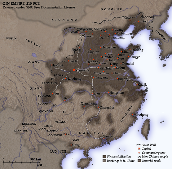
English: Map of the Qin Dynasty (in c. 210 BCE) — in China. ::*The first unifying Imperial dynasty of China. ::*The coloured territories show the approximate extent of Qin political control at the death of Emperor Qin Shi Huang in 210 BC.
As part of his unification of China in 221 BCE, Qin Shi Huang divided his empire into thirty six commanderies, each subdivided into a number of counties. The significance of the administrative reforms was its introduction of a uniformly centralised system of imperial control. At the death of Qin Shi Huang in 210 BCE, more commanderies were added to the original thirty six, and these are also shown on the map.
  • The system was followed by the Han Dynasty (206 BCE – 220 CE), though with a certain degree of compromise. Thereafter, the system became the norm for later dynasties and eventually evolved into the present administrative structure of Mainland China (see: Category: Political divisions of China.) The location of the Yellow River and commandery seats follows Tan Qixiang (ed.), Zhongguo lishi ditu (中国历史地图集), 1982. Note that the Yellow River is considerably to the north of its present flow. ;Credits Created and copyright (2006) by Yeu Ninje. Released under the GNU FDL. Originally uploaded to English Wikipedia by en:User:Yeu Ninje.
  • Han civilisation
    Han civilisation
التاريخ 1982. (2006).
المصدر Self-published work by Itsmine
المؤلف Itsmine
هذه historical map الصورة / الصورتان باستعمال رسومات متجهية ملفات رسوميات شعاعية. It is recommended to name the SVG file "Qin empire 210 BCE.svg" - then the template Vector version available (or Vva) does not need the new image name parameter.

ترخيص

أنا، صاحب حقوق التأليف والنشر لهذا العمل، أنشر هذا العمل تحت الرخص التالية:
GNU head يسمح نسخ وتوزيع و/أو تعديل هذه الوثيقة تحت شروط رخصة جنو للوثائق الحرة، الإصدار 1.2 أو أي إصدار لاحق تنشره مؤسسة البرمجيات الحرة؛ دون أقسام ثابتة ودون نصوص أغلفة أمامية ودون نصوص أغلفة خلفية. نسخة من الرخصة تم تضمينها في القسم المسمى GNU Free Documentation License.
w:ar:مشاع إبداعي
نسب العمل إلى مُؤَلِّفه الإلزام بترخيص المُشتقات بالمثل
هذا الملفُّ مُرخَّص بموجب رخصة المشاع الإبداعي نسبة المُصنَّف إِلى مُؤَلِّفه - المشاركة بالمثل 3.0 العامة
يحقُّ لك:
  • مشاركة العمل – نسخ العمل وتوزيعه وبثُّه
  • إعادة إنتاج العمل – تعديل العمل
حسب الشروط التالية:
  • نسب العمل إلى مُؤَلِّفه – يلزم نسب العمل إلى مُؤَلِّفه بشكل مناسب وتوفير رابط للرخصة وتحديد ما إذا أجريت تغييرات. بالإمكان القيام بذلك بأية طريقة معقولة، ولكن ليس بأية طريقة تشير إلى أن المرخِّص يوافقك على الاستعمال.
  • الإلزام بترخيص المُشتقات بالمثل – إذا أعدت إنتاج المواد أو غيرت فيها، فيلزم أن تنشر مساهماتك المُشتقَّة عن الأصل تحت ترخيص الأصل نفسه أو تحت ترخيص مُتوافِقٍ معه.
تمت إضافة علامة الترخيص لهذا الملف كجزء من رخصة جنو للوثائق الحرة تحديث الترخيص.
لك أن تختار الرخصة التي تناسبك.

الشروحات

أضف شرحاً من سطر واحد لما يُمثِّله هذا الملف
A map of the Qin Dynasty circa 210 BCE.

العناصر المصورة في هذا الملف

يُصوِّر

تاريخ الملف

اضغط على زمن/تاريخ لرؤية الملف كما بدا في هذا الزمن.

زمن/تاريخصورة مصغرةالأبعادمستخدمتعليق
حالي14:37، 10 ديسمبر 2014تصغير للنسخة بتاريخ 14:37، 10 ديسمبر 2014555 × 545 (567 كيلوبايت)Nguyen1310Update to include ''Luo-Yue'' (Vi: ''Lạc Việt'') a member of the Baiyue (100 Yue) peoples, on the map in northern Vietnam.
14:08، 21 نوفمبر 2006تصغير للنسخة بتاريخ 14:08، 21 نوفمبر 2006555 × 545 (540 كيلوبايت)Itsmine== Commentary == As part of his unification of China in 221 BC, Qin Shi Huang divided his empire into thirty six commanderies, each subdivided into a number of counties. The significance of the administrative reforms was its in

الصفحتان التاليتان تستخدمان هذا الملف:

الاستخدام العالمي للملف

الويكيات الأخرى التالية تستخدم هذا الملف:

اعرض المزيد من الاستخدام العام لهذا الملف.