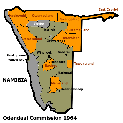
ملف:Plan Odendaal.png
Plan_Odendaal.png (418 × 418 بكسل حجم الملف: 33 كيلوبايت، نوع MIME: image/png)
تاريخ الملف
اضغط على زمن/تاريخ لرؤية الملف كما بدا في هذا الزمن.
| زمن/تاريخ | صورة مصغرة | الأبعاد | مستخدم | تعليق | |
|---|---|---|---|---|---|
| حالي | 22:00، 25 نوفمبر 2023 |  | 418 × 418 (33 كيلوبايت) | LoomCreek | Transparency |
| 07:40، 21 أبريل 2005 |  | 418 × 418 (15 كيلوبايت) | Bries | This map shows the Odendaal Commission Plan for Namibia of 1964. The plan divided Namibia into ''Bantustans'' or ''Homelands''. I have created the map for the Wikipedia community. Category:Maps of Namibia {{GFDL}} |
استخدام الملف
الصفحة التالية تستخدم هذا الملف:
الاستخدام العالمي للملف
الويكيات الأخرى التالية تستخدم هذا الملف:
- الاستخدام في af.wikipedia.org
- الاستخدام في ast.wikipedia.org
- الاستخدام في bn.wikipedia.org
- الاستخدام في ca.wikipedia.org
- Bantustan
- Hereros
- Resolució 301 del Consell de Seguretat de les Nacions Unides
- Resolució 309 del Consell de Seguretat de les Nacions Unides
- Resolució 310 del Consell de Seguretat de les Nacions Unides
- Resolució 319 del Consell de Seguretat de les Nacions Unides
- Resolució 323 del Consell de Seguretat de les Nacions Unides
- Resolució 342 del Consell de Seguretat de les Nacions Unides
- Resolució 366 del Consell de Seguretat de les Nacions Unides
- الاستخدام في ckb.wikipedia.org
- الاستخدام في de.wikipedia.org
- الاستخدام في en.wikipedia.org
- South West Africa
- History of Namibia
- Bantustan
- Kaokoland
- Bushmanland (South West Africa)
- Hereroland
- Ovamboland
- Damaraland
- Tswanaland
- Kavangoland
- Rehoboth (homeland)
- Namaland
- East Caprivi
- Fox Odendaal
- Diocese of Namibia
- United Nations Security Council Resolution 301
- Land reform in Namibia
- Aminuis
- Constance Kgosiemang
- الاستخدام في es.wikipedia.org
اعرض المزيد من الاستخدام العام لهذا الملف.


