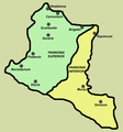
ملف:Pannonia02.png

حجم هذه المعاينة: 668 × 599 بكسل. الأبعاد الأخرى: 268 × 240 بكسل | 535 × 480 بكسل | 1٬001 × 898 بكسل.
الملف الأصلي (1٬001 × 898 بكسل حجم الملف: 75 كيلوبايت، نوع MIME: image/png)
تاريخ الملف
اضغط على زمن/تاريخ لرؤية الملف كما بدا في هذا الزمن.
| زمن/تاريخ | صورة مصغرة | الأبعاد | مستخدم | تعليق | |
|---|---|---|---|---|---|
| حالي | 15:54، 8 أبريل 2010 |  | 1٬001 × 898 (75 كيلوبايت) | WikiEditor2004 | improved version |
| 14:34، 26 يوليو 2007 |  | 702 × 751 (12 كيلوبايت) | Nihad Hamzic | Losslessly reduced the color domain to 4-bit. The file size is much smaller. | |
| 23:54، 23 ديسمبر 2006 |  | 702 × 751 (39 كيلوبايت) | Electionworld | {{ew|en|PANONIAN}} historic map (self made) {{PD-self}} Category:Maps of the history of Vojvodina Category:Maps of the history of Serbia Category:Maps of the history of Croatia Category:Maps of the history of Bosnia and Herzegovina [[Categ |
استخدام الملف
الصفحة التالية تستخدم هذا الملف:
الاستخدام العالمي للملف
الويكيات الأخرى التالية تستخدم هذا الملف:
- الاستخدام في af.wikipedia.org
- الاستخدام في ast.wikipedia.org
- الاستخدام في be.wikipedia.org
- الاستخدام في bg.wikipedia.org
- الاستخدام في br.wikipedia.org
- الاستخدام في ca.wikipedia.org
- الاستخدام في cs.wikipedia.org
- الاستخدام في el.wikipedia.org
- الاستخدام في en.wikipedia.org
- الاستخدام في et.wikipedia.org
- الاستخدام في fa.wikipedia.org
- الاستخدام في fi.wikipedia.org
- الاستخدام في fr.wikipedia.org
- الاستخدام في fr.wiktionary.org
- الاستخدام في gl.wikipedia.org
- الاستخدام في hi.wikipedia.org
- الاستخدام في hr.wikipedia.org
- الاستخدام في hu.wikipedia.org
- الاستخدام في it.wikipedia.org
- الاستخدام في ja.wikipedia.org
- الاستخدام في ka.wikipedia.org
- الاستخدام في ko.wikipedia.org
- الاستخدام في la.wikipedia.org
اعرض المزيد من الاستخدام العام لهذا الملف.
