الملف الأصلي (1٬256 × 656 بكسل حجم الملف: 75 كيلوبايت، نوع MIME: image/png)

يمكن لأي مستخدم مؤكد تلقائيًا استبدال هذه الصورة من نفس المصدر. يرجى التأكد من أن الاستبدالات تتوافق مع الإرشادات.

ملخص

هذه map الصورة / الصورتان باستعمال رسومات متجهية ملفات رسوميات شعاعية. It is recommended to name the SVG file "Ocean drainage.svg" - then the template Vector version available (or Vva) does not need the new image name parameter.
الوصف
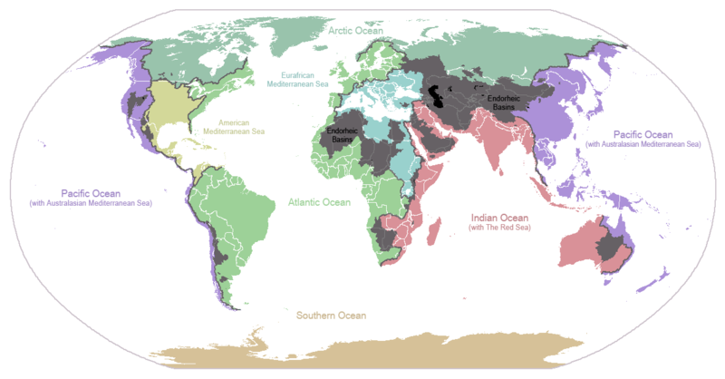
English: I made this map and hereby release it into the public domain. It shows the drainage basins for the major oceans and seas; grey areas are endorheic basins that do not drain to the ocean. Data is from the USGS Hydro1k project; information for Saskatchewan corrected by information from the Commission for Environmental Cooperation -- Citynoise
Description in large font size is used for oceans, in smaller font size is used for mediterranean seas. Only these mediterranean seas are listed which correspond to the definition of german Geographer Ernst Neef: A mediterranean sea is a sea between two Continents. Also found here: de:Mittelmeer --W like wiki (talk) 00:55, 12 March 2011 (UTC)
Français : Carte du monde des bassins versants. Les zones de couleur anthracite représentent les bassins endoréiques, qui ne sont reliés à aucun océan.
Čeština: Úmoří světových oceánů, popř. významných moří či zálivů. Legenda úmoří: fialová - Tichý oceán, růžová - Indický oceán, zelená - Atlantický oceán, azurová - Severní ledový oceán, béžová - Jižní oceán, modrá - Mexický záliv, světle modrá - Středozemní moře, šedá - oblast neústící ve světovém oceánu
التاريخ ٢٤ يناير ٢٠٠٧ (تاريخ الرفع الأصيل)
المصدر نُقِلت من en.wikipedia إلى كُومُنز .
المؤلف Citynoise في ويكيبيديا الإنجليزية
إصدارات أخرى File:Major endorheic basins.png

ترخيص

Public domain وضع -Citynoise في ويكيبيديا الإنجليزية-، وهو المؤلف، هذا العمل في النِّطاق العامِّ. يسري ذلك في كل أرجاء العالم.
في بعض البلدان، قد يكون هذا التَّرخيص غيرَ مُمكنٍ قانونيَّاً، في هذه الحالة:
يمنح Citynoise الجميع حق استخدام هذا العمل
لأي غرض دون أي شرط ما لم يفرض القانون شروطًا إضافية.

سجلُّ الرَّفع الأصيل

صفحة الوصف الأصلية كانت هنا، تشير جميع أسماء المستخدمين التالية إلى en.wikipedia.
  • 2007-05-20 17:59 Bolonium 1256×656×8 (50194 bytes) I made this map and hereby release it into the public domain. It shows the drainage basins for the major oceans and seas; grey areas are endorheic basins that do not drain to the ocean. -- [[User:Citynoise|Citynoise]] == Licensing == {{self
  • 2007-01-24 07:21 Citynoise 1256×656×8 (63359 bytes) I made this map and hereby release it into the public domain. It shows the drainage basins for the major oceans and seas; grey areas are endorheic basins that do not drain to the ocean.
  • 2007-01-24 06:09 Citynoise 1256×656×8 (57358 bytes) I made this map and hereby release it into the public domain. It shows the drainage basins for the major oceans and seas; grey areas are endorheic basins that do not drain to the ocean.
  • 2007-01-24 05:10 Citynoise 1256×656×8 (56360 bytes) I made this map and hereby release it into the public domain. It shows the drainage basins for the major oceans and seas; grey areas are endorheic basins that do not drain to the ocean.
  • 2007-01-24 04:55 Citynoise 1256×656×8 (56373 bytes) I made this map and hereby release it into the public domain. It shows the drainage basins for the major oceans and seas; grey areas are endorheic basins that do not drain to the ocean.

الشروحات

أضف شرحاً من سطر واحد لما يُمثِّله هذا الملف
Drainage basins of the world, colored by ocean outlet. Endorheic basins not draining to an ocean are colored dark gray. Continental divides are indicated by dark lines.

العناصر المصورة في هذا الملف

يُصوِّر

٢٤ يناير 2007

٧٦٬٦٣١ بايت

٦٥٦ بكسل

١٬٢٥٦ بكسل

تاريخ الملف

اضغط على زمن/تاريخ لرؤية الملف كما بدا في هذا الزمن.

زمن/تاريخصورة مصغرةالأبعادمستخدمتعليق
حالي23:25، 6 أكتوبر 2015تصغير للنسخة بتاريخ 23:25، 6 أكتوبر 20151٬256 × 656 (75 كيلوبايت)AcidSnowFixed Somalia.
00:39، 12 مارس 2011تصغير للنسخة بتاريخ 00:39، 12 مارس 20111٬256 × 656 (76 كيلوبايت)W like wikiInsert Description. Big font size is used for oceans, smaller font size is used for mediterranean seas.
11:13، 30 يونيو 2009تصغير للنسخة بتاريخ 11:13، 30 يونيو 20091٬256 × 656 (40 كيلوبايت)U7vGuntransparentize background,improve some details.
20:45، 26 يوليو 2008تصغير للنسخة بتاريخ 20:45، 26 يوليو 20081٬256 × 656 (62 كيلوبايت)Citynoise{{Information |Description=added endorheic basins in Saskatchewan. |Source=my own work |Date=July 2008 |Author=Citynoise |Permission=all rights released |other_versions= }}
19:46، 27 نوفمبر 2007تصغير للنسخة بتاريخ 19:46، 27 نوفمبر 20071٬256 × 656 (49 كيلوبايت)File Upload Bot (Magnus Manske) {{BotMoveToCommons|en.wikipedia}} {{Information |Description={{en|I made this map and hereby release it into the public domain. It shows the drainage basins for the major oceans and seas; grey areas are en:endorheic basins that do not drain to the

ال3 صفحات التالية تستخدم هذا الملف:

الاستخدام العالمي للملف

الويكيات الأخرى التالية تستخدم هذا الملف:

اعرض المزيد من الاستخدام العام لهذا الملف.

بيانات وصفية