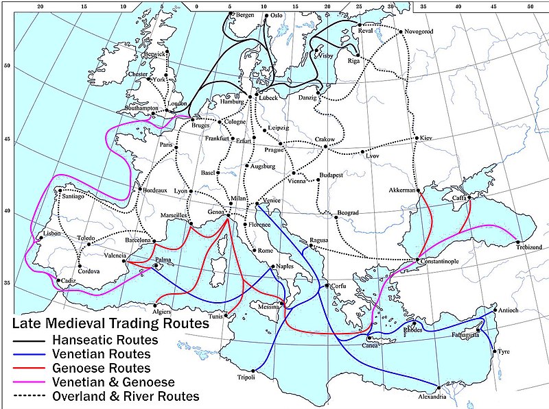
ملف:Late Medieval Trade Routes.jpg

حجم هذه المعاينة: 800 × 597 بكسل. الأبعاد الأخرى: 320 × 239 بكسل | 640 × 478 بكسل | 1٬024 × 765 بكسل | 1٬280 × 956 بكسل | 1٬457 × 1٬088 بكسل.
الملف الأصلي (1٬457 × 1٬088 بكسل حجم الملف: 372 كيلوبايت، نوع MIME: image/jpeg)
تاريخ الملف
اضغط على زمن/تاريخ لرؤية الملف كما بدا في هذا الزمن.
| زمن/تاريخ | صورة مصغرة | الأبعاد | مستخدم | تعليق | |
|---|---|---|---|---|---|
| حالي | 20:46، 18 مايو 2022 |  | 1٬457 × 1٬088 (372 كيلوبايت) | Richard2s | Clearer key for map |
| 20:25، 23 يناير 2011 |  | 853 × 544 (453 كيلوبايت) | Micsha~commonswiki | Includes map key on the map | |
| 15:55، 28 مارس 2008 |  | 1٬817 × 1٬120 (487 كيلوبايت) | Lampman | {{Information |Description=Map showing the main trade routes of late medieval Europe. The black lines show the routes of the Hanseatic League, the blue Venetian and the red Genoese routes. Purple lines are routes used by both the Venetians and the Genoese |
استخدام الملف
ال3 صفحات التالية تستخدم هذا الملف:
الاستخدام العالمي للملف
الويكيات الأخرى التالية تستخدم هذا الملف:
- الاستخدام في be-tarask.wikipedia.org
- الاستخدام في bg.wikipedia.org
- الاستخدام في ca.wikipedia.org
- الاستخدام في da.wikipedia.org
- الاستخدام في el.wikipedia.org
- الاستخدام في en.wikipedia.org
- Economics
- Trade
- Late Middle Ages
- Portal:Economics
- Wikipedia:Picture peer review/Archives/Jan-Mar 2008
- Wikipedia:Picture peer review/Late medieval trade routes
- Wikipedia:Valued picture candidates/January-2009
- Wikipedia:Valued picture candidates/Late Medieval Trade Routes
- Islamic influences on Western art
- الاستخدام في es.wikipedia.org
- الاستخدام في et.wikipedia.org
- الاستخدام في fr.wikipedia.org
- الاستخدام في he.wikipedia.org
- الاستخدام في hy.wikipedia.org
- الاستخدام في it.wikipedia.org
- الاستخدام في ja.wikipedia.org
- الاستخدام في mk.wikipedia.org
- الاستخدام في nl.wikipedia.org
- الاستخدام في pl.wikipedia.org
- الاستخدام في pt.wikipedia.org
- الاستخدام في rm.wikipedia.org
- الاستخدام في sh.wikipedia.org
- الاستخدام في sl.wikipedia.org
- الاستخدام في sq.wikipedia.org
- الاستخدام في th.wikipedia.org
- الاستخدام في uk.wikipedia.org
اعرض المزيد من الاستخدام العام لهذا الملف.

