ملف:Kingdoms of the Levant Map 830.xcf
حجم معاينة PNG لذلك الملف ذي الامتداد XCF: 503 × 600 بكسل. الأبعاد الأخرى: 201 × 240 بكسل | 402 × 480 بكسل | 644 × 768 بكسل | 858 × 1٬024 بكسل | 1٬955 × 2٬332 بكسل.
الملف الأصلي (1٬955 × 2٬332 بكسل حجم الملف: 941 كيلوبايت، نوع MIME: image/x-xcf)
| هذا ملف من ويكيميديا كومنز. معلومات من صفحة وصفه مبينة في الأسفل.
كومنز مستودع ملفات ميديا ذو رخصة حرة. |
|
.هذا الرسم المتجهي أُنشئ بواسطة GIMP
|
ملخص
| الوصف |
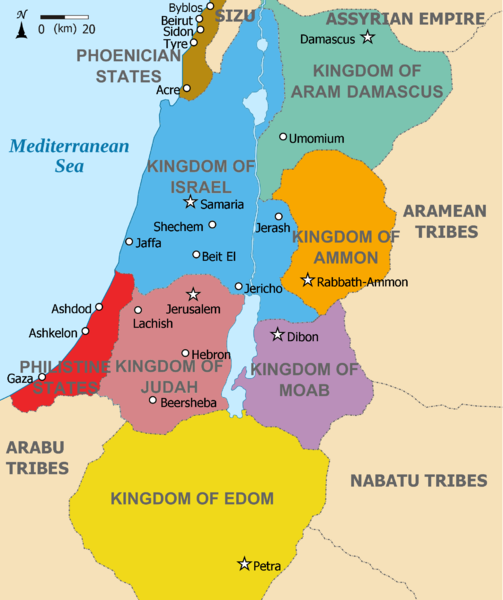
English: Map showing Kingdoms of the Levant c 830. The Kingdoms:
العربية: خريطة توضح ممالك بلاد الشام ج 830. الممالك:
فينيقيا - بني ارام دمشق - زبرجد آمون - البرتقالي موآب - بنفسجي ايدوم - الأصفر فلسطين - أحمر يهوذا - مارون تُظهر الخريطة المنطقة في القرن التاسع قبل الميلاد. |
| التاريخ | (UTC) |
| المصدر |
هذا الملفُّ مُشتقٌ مِن : |
| المؤلف |
|
| إصدارات أخرى | أَعمالٌ مُشتقَّة مِن هذا الملفِّ: Kingdoms of the Levant Map 830.png |


| هذا رسمٌ مُعَدَّلٌ رقميَّاً من النسخة الأصليَّة. التعديلات هي: Added colours for the two kingdoms. يُمكن الاطلاع على النسخة الأصليَّة هنا: Kingdoms of Israel and Judah map 830.svg:
|
ترخيص
هذا الملفُّ مُرخَّص بموجب رخصة المشاع الإبداعي نسبة المُصنَّف إِلى مُؤَلِّفه - المشاركة بالمثل 3.0 العامة
- يحقُّ لك:
- مشاركة العمل – نسخ العمل وتوزيعه وبثُّه
- إعادة إنتاج العمل – تعديل العمل
- حسب الشروط التالية:
- نسب العمل إلى مُؤَلِّفه – يلزم نسب العمل إلى مُؤَلِّفه بشكل مناسب وتوفير رابط للرخصة وتحديد ما إذا أجريت تغييرات. بالإمكان القيام بذلك بأية طريقة معقولة، ولكن ليس بأية طريقة تشير إلى أن المرخِّص يوافقك على الاستعمال.
- الإلزام بترخيص المُشتقات بالمثل – إذا أعدت إنتاج المواد أو غيرت فيها، فيلزم أن تنشر مساهماتك المُشتقَّة عن الأصل تحت ترخيص الأصل نفسه أو تحت ترخيص مُتوافِقٍ معه.
سجلُّ الرَّفع الأصيل
This image is a derivative work of the following images:
- File:Kingdoms_around_Israel_830_map.svg licensed with Cc-by-sa-3.0, GFDL
- 2010-07-13T12:58:31Z Richardprins 720x859 (169373 Bytes) livened up the colors, converted med sea text to path
- 2010-07-13T11:26:40Z Richardprins 720x859 (141985 Bytes) {{Information |Description={{en|1=Map showing the ancient levant borders and ancient cities such as [[Urmomium]] and [[Jerash]]. The Kingdoms around Israel and Judah are colored. The map also shows the region in the 9th centu
- File:Kingdoms_of_Israel_and_Judah_map_830.svg licensed with Cc-by-sa-3.0, GFDL
- 2011-02-12T23:48:05Z Richardprins 720x859 (80190 Bytes) -
- 2010-07-13T11:29:47Z Richardprins 720x859 (80899 Bytes) Fixed Judah color
- 2010-07-13T10:51:49Z Richardprins 720x859 (80858 Bytes) Added colors for the two kingdoms and converted their text to path and arial
- 2010-07-12T23:53:35Z Richardprins 720x859 (63843 Bytes) Shrinked down the borders
- 2010-07-12T19:43:31Z Richardprins 720x859 (63800 Bytes) {{Information |Description={{en|1=Map showing the ancient levant borders and ancient cities such as [[Urmomium]] and [[Jerash]]. The map also shows the region in the 9th century BCE. Notice the coastal land of Philistia, from
Uploaded with derivativeFX
تاريخ الملف
اضغط على زمن/تاريخ لرؤية الملف كما بدا في هذا الزمن.
| زمن/تاريخ | صورة مصغرة | الأبعاد | مستخدم | تعليق | |
|---|---|---|---|---|---|
| حالي | 11:26، 12 مارس 2012 |  | 1٬955 × 2٬332 (941 كيلوبايت) | Dlv999 | == {{int:filedesc}} == {{Information |Description={{en|1=Map showing Kingdoms of the Levant c 830. The Kingdoms: * Phoenicia -Brown * Aram Damascus - Aquamarine * Amon - Orange * Moab - Purple * Edom - Yellow * Philistia - Red * Israel - Blue) *... |
استخدام الملف
الصفحة التالية تستخدم هذا الملف:
الاستخدام العالمي للملف
الويكيات الأخرى التالية تستخدم هذا الملف:
- الاستخدام في en.wikipedia.org
- الاستخدام في hr.wikipedia.org
- الاستخدام في mg.wikipedia.org