ملف:John-Tallis-1851-Tibet-Mongolia-and-Manchuria-33621.jpg

حجم هذه المعاينة: 779 × 600 بكسل. الأبعاد الأخرى: 312 × 240 بكسل | 624 × 480 بكسل | 998 × 768 بكسل | 1٬280 × 985 بكسل | 2٬560 × 1٬971 بكسل | 4٬030 × 3٬102 بكسل.
الملف الأصلي (4٬030 × 3٬102 بكسل حجم الملف: 12٫64 ميجابايت، نوع MIME: image/jpeg)
| هذا ملف من ويكيميديا كومنز. معلومات من صفحة وصفه مبينة في الأسفل. كومنز مستودع ملفات ميديا ذو رخصة حرة. |
ملخص
| الوصف |
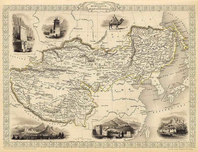
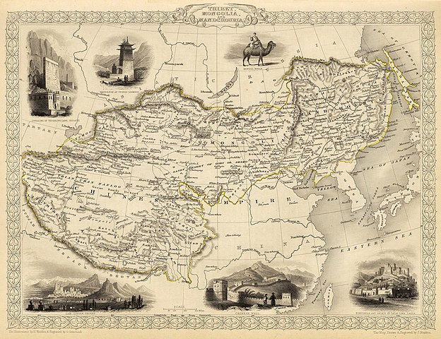
English: Map of the northern and western part of the Chinese Empire - "Thibet, Mongolia, and Mandchouria". The borders are shown as per the 1686 Treaty of Nerchinsk. (They were to be changed drastically in 1858-60, by treaty of Aigun and subsequent agreements). The main Russian center in Transbaikalia is still Nerchinsk, rather than Chita. The outline of Sakhalin Island is already shown fairly correctly, but the body of water separating it from the mainland is still labeled "Gulf of Tartary" (rather than '"Strait).
Français : Carte des parties Nord et Ouest de l'Empire chinois — « Thibet, Mongolie and Mandchourie ». Les frontières sont montrées telles qu'elles étaient définies par le Traité de Nerchinsk de 1686. (Elles allaient être grandement changées en 1858-1860 par le traité d'Aigun et les accords suivants). Le principal centre russe en Transbaïkalie est encore Nerchinsk, plutôt que Chita. Le contour de l'île Sakhaline est déjà décrit très correctement, mais l'étendue d'eau la séparant du continent est encore qualifiée de « golfe de Tartarie » (plutôt que « détroit »).
中文:中国皇国,北部和西部。 |
| التاريخ | |
| المصدر | John Tallis' atlas of the world. Reproduced at http://www.davidrumsey.com/luna/servlet/detail/RUMSEY~8~1~821~60126:Thibet,-Mongolia,-and-Mandchouria-- (the last version uploaded is from there), http://www.jpmaps.co.uk/mapimages/originals/33621.jpg , and elsewhere |
| المؤلف | Martin, R.M.; Tallis, J. & F. The staff of John Tallis: The Illustrations by H. Winkles & Engraved by G. Greatbach. The Map Drawn & Engraved by J. Rapkin. |
| إصدارات أخرى | أَعمالٌ مُشتقَّة مِن هذا الملفِّ: John-Tallis-1851-Tibet-Mongolia-and-Manchuria-NE.jpg |
ترخيص
|
هذا العمل يقع في النَّطاق العامّ في بلد المنشأ وفي البلدان الأخرى والمناطق التي تمتدُّ فيها مدة حقوق التَّأليف والنشر لتغطي زمن حياة المُؤلِّف و 70 سنةً بعد وفاته أو أقل من ذلك. | |
| هذا الملفُّ مَلحُوظُ بصفته غيرَ مُقيَّدٍ بحقوق التَّأليف والنشر، وهذا يشمل أيضاً الحقوق المُجاوِرة أَو ذات الصلة جميعُها. | |
تاريخ الملف
اضغط على زمن/تاريخ لرؤية الملف كما بدا في هذا الزمن.
| زمن/تاريخ | صورة مصغرة | الأبعاد | مستخدم | تعليق | |
|---|---|---|---|---|---|
| حالي | 20:51، 28 فبراير 2016 | | 4٬030 × 3٬102 (12٫64 ميجابايت) | Centpacrr | Crop |
| 02:26، 7 ديسمبر 2009 |  | 4٬700 × 3٬750 (4٫07 ميجابايت) | Vmenkov | better resolution, as available from http://www.davidrumsey.com/luna/servlet/detail/RUMSEY~8~1~821~60126:Thibet,-Mongolia,-and-Mandchouria-- | |
| 01:38، 7 ديسمبر 2009 |  | 1٬289 × 989 (386 كيلوبايت) | Vmenkov | {{Information |Description={{en|1=Map of the northern and western part of the Chinese Empire - "Thibet, Mongolia, and Mandchouria". The borders are shows as per the 1858 treaty of Aigun. The main Russian center in Transbaikalia is still Nerchinsk, rather |
استخدام الملف
الصفحة التالية تستخدم هذا الملف:
الاستخدام العالمي للملف
الويكيات الأخرى التالية تستخدم هذا الملف:
- الاستخدام في el.wikipedia.org
- الاستخدام في en.wikipedia.org
- الاستخدام في fr.wikipedia.org
- الاستخدام في hr.wikipedia.org
- الاستخدام في ko.wikipedia.org
- الاستخدام في mn.wikipedia.org
- الاستخدام في sh.wikipedia.org
- الاستخدام في vi.wikipedia.org