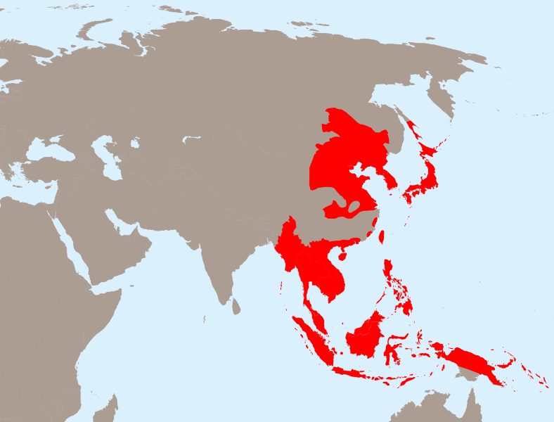
ملف:Japanese Empire - 1942.svg

حجم معاينة PNG لذلك الملف ذي الامتداد SVG: 788 × 600 بكسل. الأبعاد الأخرى: 316 × 240 بكسل | 631 × 480 بكسل | 1٬009 × 768 بكسل | 1٬280 × 974 بكسل | 2٬560 × 1٬948 بكسل | 1٬100 × 837 بكسل.
الملف الأصلي (ملف SVG، أبعاده 1٬100 × 837 بكسل، حجم الملف: 875 كيلوبايت)
تاريخ الملف
اضغط على زمن/تاريخ لرؤية الملف كما بدا في هذا الزمن.
| زمن/تاريخ | صورة مصغرة | الأبعاد | مستخدم | تعليق | |
|---|---|---|---|---|---|
| حالي | 20:13، 31 مارس 2020 |  | 1٬100 × 837 (875 كيلوبايت) | Esmu Igors | Northern part of the Sakhalin island was transferred from Japan to Soviet Russia in 1925, and the borders remained untouched until the end of WWII. Hence this territory should be omitted from the map. |
| 20:13، 31 مارس 2020 |  | 1٬100 × 837 (904 كيلوبايت) | Esmu Igors | Reverted to version as of 01:24, 25 April 2010 (UTC) (unsuccessful edit in the Inkscape) | |
| 20:11، 31 مارس 2020 |  | 1٬100 × 837 (882 كيلوبايت) | Esmu Igors | Northern part of the Sakhalin island was transferred from Japan to Soviet Russia in 1925, and the borders remained untouched until the end of WWII. Hence this territory should be omitted from the map. | |
| 01:24، 25 أبريل 2010 |  | 1٬100 × 837 (904 كيلوبايت) | Ras67 | borders removed | |
| 21:44، 23 أبريل 2010 |  | 1٬100 × 837 (911 كيلوبايت) | TastyCakes | Tweaked some borders and coloured some islands that I missed | |
| 21:29، 23 أبريل 2010 |  | 1٬100 × 837 (911 كيلوبايت) | TastyCakes | {{Information |Description={{en|The Empire of Japan at its height in 1942.}} {{fr}}Carte vierge de l'Asie {{en}}Asia Blank map |Source=*File:Empire_of_Japan_(1868-1945).png *File:Asie.svg *File:Japanese_Empire2.png |Date=2010-04-23 21:26 |
استخدام الملف
الصفحتان التاليتان تستخدمان هذا الملف:
الاستخدام العالمي للملف
الويكيات الأخرى التالية تستخدم هذا الملف:
- الاستخدام في bcl.wikipedia.org
- الاستخدام في be.wikipedia.org
- الاستخدام في cs.wikipedia.org
- الاستخدام في de.wikipedia.org
- الاستخدام في en.wikipedia.org
- الاستخدام في fo.wikipedia.org
- الاستخدام في fr.wikipedia.org
- الاستخدام في id.wikipedia.org
- الاستخدام في it.wikipedia.org
- الاستخدام في ja.wikipedia.org
- الاستخدام في km.wikipedia.org
- الاستخدام في ms.wikipedia.org
- الاستخدام في no.wikipedia.org
- الاستخدام في ru.wikipedia.org
- الاستخدام في simple.wikipedia.org
- الاستخدام في sv.wikipedia.org
- الاستخدام في th.wikipedia.org
- الاستخدام في tl.wikipedia.org
- الاستخدام في uk.wikipedia.org
- الاستخدام في zh-min-nan.wikipedia.org
- الاستخدام في zh-yue.wikipedia.org
- الاستخدام في zh.wikipedia.org
اعرض المزيد من الاستخدام العام لهذا الملف.