ملف:Iran - Location Map (2013) - IRN - UNOCHA.svg

الملف الأصلي (ملف SVG، أبعاده 250 × 250 بكسل، حجم الملف: 772 كيلوبايت)
| هذا ملف من ويكيميديا كومنز. معلومات من صفحة وصفه مبينة في الأسفل. كومنز مستودع ملفات ميديا ذو رخصة حرة. |
_-_IRN_-_UNOCHA.svg)
ملخص
| الوصف |
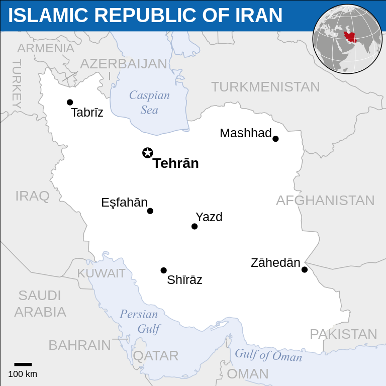
English: Locator map of Iran. |
| التاريخ | |
| المصدر |
English: Iran (Islamic Republic of) Locator Map (ReliefWeb), ESRI, UNCS |
| المؤلف | |
| SVG منشأ الملف |
ترخيص
- يحقُّ لك:
- مشاركة العمل – نسخ العمل وتوزيعه وبثُّه
- إعادة إنتاج العمل – تعديل العمل
- حسب الشروط التالية:
- نسب العمل إلى مُؤَلِّفه – يلزم نسب العمل إلى مُؤَلِّفه بشكل مناسب وتوفير رابط للرخصة وتحديد ما إذا أجريت تغييرات. بالإمكان القيام بذلك بأية طريقة معقولة، ولكن ليس بأية طريقة تشير إلى أن المرخِّص يوافقك على الاستعمال.
 This map is part of a collection of 216 free country maps, created by the UN Office for the Coordination of Humanitarian Affairs (OCHA), to be used in print, web or broadcast products.
The ReliefWeb Location Maps released here are maps that highlight a country, its capital, major populated places and the surrounding regions. Attribution Requirements
Using the map without modifications: ensure that the sources and the disclaimer are below the map. Credit as follows: "Credit: OCHA". For use with alteration: remove the OCHA logo and disclaimer following any modification to the map, but keep the data sources as mentioned below the map. Credit the modified map as follows: "Based on OCHA map". You are responsible for the content of your map. We are keen to receive your feedback and hear how you used OCHA's maps. We would be grateful if you would notify us by e-mail and share your work with us. UN Disclaimer
The designations employed and the presentation of material of this map do not imply the expression of any opinion whatsoever on the part of the Secretariat of the United Nations concerning the legal status of any country, territory, city or area or of its authorities or concerning the delimitation of its frontiers or boundaries. |
تاريخ الملف
اضغط على زمن/تاريخ لرؤية الملف كما بدا في هذا الزمن.
| زمن/تاريخ | صورة مصغرة | الأبعاد | مستخدم | تعليق | |
|---|---|---|---|---|---|
| حالي | 03:40، 19 نوفمبر 2022 | | 250 × 250 (772 كيلوبايت) | Pengetik-AM | File uploaded using svgtranslate tool (https://svgtranslate.toolforge.org/). Added translation for id. |
| 14:35، 3 سبتمبر 2021 |  | 250 × 250 (771 كيلوبايت) | Darafsh | File uploaded using svgtranslate tool (https://svgtranslate.toolforge.org/). Added translation for fa. | |
| 07:25، 20 أغسطس 2016 |  | 250 × 250 (765 كيلوبايت) | Wereldburger758 | Resized page to drawing. Removal watermark. Validation of image. | |
| 03:19، 21 أبريل 2014 |  | 254 × 254 (766 كيلوبايت) | UN OCHA maps bot | == {{int:filedesc}} == {{Information |description={{en|1=Locator map of Iran.}} |date=2013 |source={{en|1=[http://reliefweb.int/map/iran-islamic-republic/islamic-republic-iran-location-map-2013 Iran (Islamic Republic of) Locator Map (Reli... |
استخدام الملف
الصفحة التالية تستخدم هذا الملف:
الاستخدام العالمي للملف
الويكيات الأخرى التالية تستخدم هذا الملف:
- الاستخدام في btm.wikipedia.org
- الاستخدام في ckb.wikipedia.org
- الاستخدام في dtp.wikipedia.org
- الاستخدام في en.wikipedia.org
- الاستخدام في es.wikipedia.org
- الاستخدام في fa.wikipedia.org
- الاستخدام في id.wikipedia.org
- الاستخدام في incubator.wikimedia.org
- الاستخدام في ka.wikipedia.org
- الاستخدام في si.wikipedia.org
_-_IRN_-_UNOCHA.svg)