Emoriches.png (422 × 359 بكسل حجم الملف: 17 كيلوبايت، نوع MIME: image/png)

ملخص

الوصف
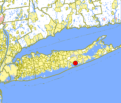
English: Map showing the location of East Moriches on Long Island. US Government Census map from
المصدر http://tiger.census.gov/cgi-bin/mapsurfer?act=in&infact=1.05&outfact=2&tlevel=-&tvar=-&tmeth=i&mlat=40.806287&mlon=-72.756735&msym=bigdot&mlabel=&murl=&lat=40.9430237&lon=-73.0569916&wid=1.364&ht=1.364&conf=mapnew.con&map.x=221&map.y=175
المؤلف

ترخيص

Public domain
This image or file is a work of a United States Census Bureau employee, taken or made as part of that person's official duties. As a work of the U.S. federal government, the image is in the public domain.

English  español  日本語  македонски  മലയാളം  português do Brasil  русский  українська  עברית  +/−


سجلُّ الرَّفع الأصيل

نُقِلت من en.wikipedia إلى كُومُنز بواسطة Milicevic01 باستخدام CommonsHelper.

صفحة الوصف الأصلية كانت هنا، تشير جميع أسماء المستخدمين التالية إلى en.wikipedia.
  • 2007-01-23 19:42 Badagnani 422×359× (15358 bytes) Map showing the location of [[East Moriches, New York]] on [[Long Island]]. US Government Census map from http://tiger.census.gov/cgi-bin/mapsurfer?act=in&infact=1.05&outfact=2&tlevel=-&tvar=-&tmeth=i&mlat=40.806287&mlon=-72.756735&msym=bigdot&mlabel=&mu

سجلُّ الرَّفع الأصيل

زمن/تاريخ الأبعاد مستخدم تعليق
٢٣ أغسطس ٢٠١٣, ١٠:٠١:٤٥ 422 × 359 (15358 bytes) File Upload Bot (Magnus Manske) (نقاش · مساهمات) Transfered from en.wikipedia by [[User:Milicevic01]] using CommonsHelper

الشروحات

أضف شرحاً من سطر واحد لما يُمثِّله هذا الملف

العناصر المصورة في هذا الملف

يُصوِّر

تاريخ الملف

اضغط على زمن/تاريخ لرؤية الملف كما بدا في هذا الزمن.

زمن/تاريخصورة مصغرةالأبعادمستخدمتعليق
حالي02:03، 9 يناير 2015تصغير للنسخة بتاريخ 02:03، 9 يناير 2015422 × 359 (17 كيلوبايت)GifTaggerBot: Converting file to superior PNG file. (Source: Emoriches.gif). This GIF was problematic due to non-greyscale color table.

الصفحة التالية تستخدم هذا الملف:

الاستخدام العالمي للملف

الويكيات الأخرى التالية تستخدم هذا الملف: