ملف:Denbighshire UK location map.svg

حجم معاينة PNG لذلك الملف ذي الامتداد SVG: 397 × 600 بكسل. الأبعاد الأخرى: 159 × 240 بكسل | 318 × 480 بكسل | 508 × 768 بكسل | 678 × 1٬024 بكسل | 1٬356 × 2٬048 بكسل | 864 × 1٬305 بكسل.
الملف الأصلي (ملف SVG، أبعاده 864 × 1٬305 بكسل، حجم الملف: 767 كيلوبايت)
| هذا ملف من ويكيميديا كومنز. معلومات من صفحة وصفه مبينة في الأسفل.
كومنز مستودع ملفات ميديا ذو رخصة حرة. |
| الوصف |
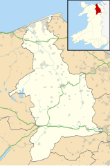
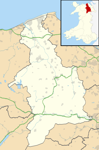
Blank map of Denbighshire, UK with the following information shown:
Equirectangular map projection on WGS 84 datum, with N/S stretched 165% Geographic limits:
|
| التاريخ | |
| المصدر |
|
| المؤلف | Nilfanion, created using Ordnance Survey data |
| الترخيص (إعادة استخدام هذا الملف) |
هذا الملفُّ مُرخَّص بموجب رخصة المشاع الإبداعي نسبة المُصنَّف إِلى مُؤَلِّفه - المشاركة بالمثل 3.0 العامة نسب العمل لمُؤَلِّفه: Contains Ordnance Survey data © Crown copyright and database right
|
| إصدارات أخرى | File:Denbighshire UK map.svg - Blank map |
تاريخ الملف
اضغط على زمن/تاريخ لرؤية الملف كما بدا في هذا الزمن.
| زمن/تاريخ | صورة مصغرة | الأبعاد | مستخدم | تعليق | |
|---|---|---|---|---|---|
| حالي | 19:32، 26 سبتمبر 2010 | | 864 × 1٬305 (767 كيلوبايت) | Nilfanion | {{Information |Description=Blank map of Denbighshire, UK with the following information shown: *Administrative borders *Coastline, lakes and rivers *Roads and railways *Urban areas Equirectangular map projection on WGS 84 datum, with N |
استخدام الملف
الصفحة التالية تستخدم هذا الملف:
الاستخدام العالمي للملف
الويكيات الأخرى التالية تستخدم هذا الملف:
- الاستخدام في azb.wikipedia.org
- الاستخدام في ceb.wikipedia.org
- الاستخدام في cy.wikipedia.org
- الاستخدام في da.wikipedia.org
- الاستخدام في en.wikipedia.org
- Llangollen
- List of monastic houses in Wales
- Ruthin
- Denbighshire
- Rhyl
- St Asaph
- Prestatyn
- Rhuddlan
- Corwen
- Denbigh
- Bodelwyddan
- Gwyddelwern
- Loggerheads, Denbighshire
- Castell Dinas Brân
- Cynwyd, Denbighshire
- Nantglyn
- Llandyrnog
- Glyndyfrdwy
- Llanarmon-yn-Iâl
- Glan Clwyd Hospital
- Denbigh Community Hospital
- H.M. Stanley Hospital
- Llangollen Community Hospital
- Prestatyn Community Hospital
- Ruthin Community Hospital
- Pot Hole quarry
- Llandegla
- Henllan
- Meliden
- Dyserth
- Llanferres
- Llanelidan
- Tremeirchion
- Trefnant
- Llandrillo, Denbighshire
- Cader
- Bodfari
- Bontuchel
- Maeshafn
- RAF Prestatyn
- Llanfair Dyffryn Clwyd
- Tafarn-y-Gelyn
- Eryrys
- User:Arwel Parry/sandbox/Infobox Browser test
- St Beuno's Jesuit Spirituality Centre
- Commins, Denbighshire
اعرض المزيد من الاستخدام العام لهذا الملف.