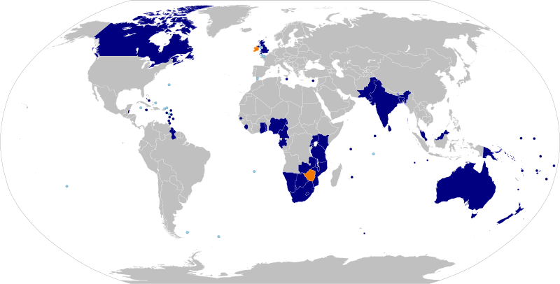
ملف:Commonwealth of Nations.svg

حجم معاينة PNG لذلك الملف ذي الامتداد SVG: 800 × 406 بكسل. الأبعاد الأخرى: 320 × 162 بكسل | 640 × 325 بكسل | 1٬024 × 520 بكسل | 1٬280 × 650 بكسل | 2٬560 × 1٬300 بكسل | 2٬754 × 1٬398 بكسل.
الملف الأصلي (ملف SVG، أبعاده 2٬754 × 1٬398 بكسل، حجم الملف: 1٫1 ميجابايت)
تاريخ الملف
اضغط على زمن/تاريخ لرؤية الملف كما بدا في هذا الزمن.
| زمن/تاريخ | صورة مصغرة | الأبعاد | مستخدم | تعليق | |
|---|---|---|---|---|---|
| حالي | 19:16، 25 يونيو 2022 |  | 2٬754 × 1٬398 (1٫1 ميجابايت) | DrKay | added Gabon and Togo |
| 12:21، 24 يناير 2022 |  | 2٬754 × 1٬398 (1٫05 ميجابايت) | Saftorangen | Rebase map on BlankMap-World.svg. Add GS and IO as overseas territories (teal) | |
| 19:19، 2 فبراير 2020 |  | 940 × 477 (1٫34 ميجابايت) | MapleCenturion | Changed Maldives to Current Member (Rejoined the Commonwealth) | |
| 07:32، 29 أبريل 2018 |  | 940 × 477 (1٫34 ميجابايت) | DrKay | Amend Gambia | |
| 01:48، 16 أكتوبر 2016 |  | 940 × 477 (1٫26 ميجابايت) | फ़िलप्रो | updated Maldives | |
| 21:12، 2 يوليو 2015 |  | 940 × 477 (1٫64 ميجابايت) | DrKay | correct French Polynesia to Pitcairn per talk | |
| 10:06، 9 أكتوبر 2014 |  | 940 × 477 (1٫64 ميجابايت) | Chipmunkdavis | Fiji now a full member again. | |
| 21:26، 3 أكتوبر 2013 |  | 940 × 477 (1٫64 ميجابايت) | Treehill | Gambia leaved the Commonwealth today. | |
| 19:45، 27 ديسمبر 2011 |  | 940 × 477 (1٫64 ميجابايت) | Bastin | This map is supposed to illustrate the Commonwealth's members and ex-members. Use your own map. | |
| 15:09، 21 ديسمبر 2011 |  | 940 × 477 (1٫25 ميجابايت) | NikNaks | Added red colour for prospective members, as per request on COM:GL/I |
استخدام الملف
الصفحة التالية تستخدم هذا الملف:
الاستخدام العالمي للملف
الويكيات الأخرى التالية تستخدم هذا الملف:
- الاستخدام في af.wikipedia.org
- الاستخدام في als.wikipedia.org
- الاستخدام في ang.wikipedia.org
- الاستخدام في arz.wikipedia.org
- الاستخدام في az.wikipedia.org
- الاستخدام في ba.wikipedia.org
- الاستخدام في be.wikipedia.org
- الاستخدام في bn.wikipedia.org
- الاستخدام في bn.wikivoyage.org
- الاستخدام في btm.wikipedia.org
- الاستخدام في ckb.wikipedia.org
- الاستخدام في cs.wikipedia.org
- الاستخدام في de.wikipedia.org
- الاستخدام في dsb.wikipedia.org
- الاستخدام في en.wikipedia.org
- English in the Commonwealth of Nations
- Talk:English in the Commonwealth of Nations
- Foreign relations of the United Kingdom
- Talk:Westminster system
- Talk:Responsible government
- Talk:Monarchy of the United Kingdom
- Talk:Received Pronunciation
- Talk:Judicial Committee of the Privy Council
- Talk:Governor General of Canada
- Talk:Netball
- Talk:Elizabeth II
- Talk:Northern Territory
- Talk:Royal assent
- Talk:Commonwealth of Nations
- Talk:British royal family
- Talk:Queensland
- Talk:Orders, decorations, and medals of the Commonwealth realms
- Talk:High commissioner
- Talk:George V
- Talk:Monarchy of Ireland
- Talk:Royal prerogative
- Talk:Canada Act 1982
- Talk:Tory
- Talk:Index of Canada-related articles
- Talk:List of titles and honours of Elizabeth II
- Talk:Public limited company
- Talk:Victoria (state)
- Talk:Governor-General of Belize
- Template talk:The Commonwealth
- Talk:List of organisations with a British royal charter
- Talk:Victory in Europe Day
- Talk:House of Windsor
- Talk:Crown copyright
- Talk:Order of the British Empire
اعرض المزيد من الاستخدام العام لهذا الملف.