ملف:Central-Eastern-Livingston-Map.png
حجم هذه المعاينة: 798 × 600 بكسل. الأبعاد الأخرى: 320 × 240 بكسل | 639 × 480 بكسل | 1٬022 × 768 بكسل | 1٬280 × 962 بكسل | 2٬560 × 1٬924 بكسل | 3٬928 × 2٬952 بكسل.
الملف الأصلي (3٬928 × 2٬952 بكسل حجم الملف: 3٫08 ميجابايت، نوع MIME: image/png)
| هذا ملف من ويكيميديا كومنز. معلومات من صفحة وصفه مبينة في الأسفل.
كومنز مستودع ملفات ميديا ذو رخصة حرة. |
ملخص
| الوصف |
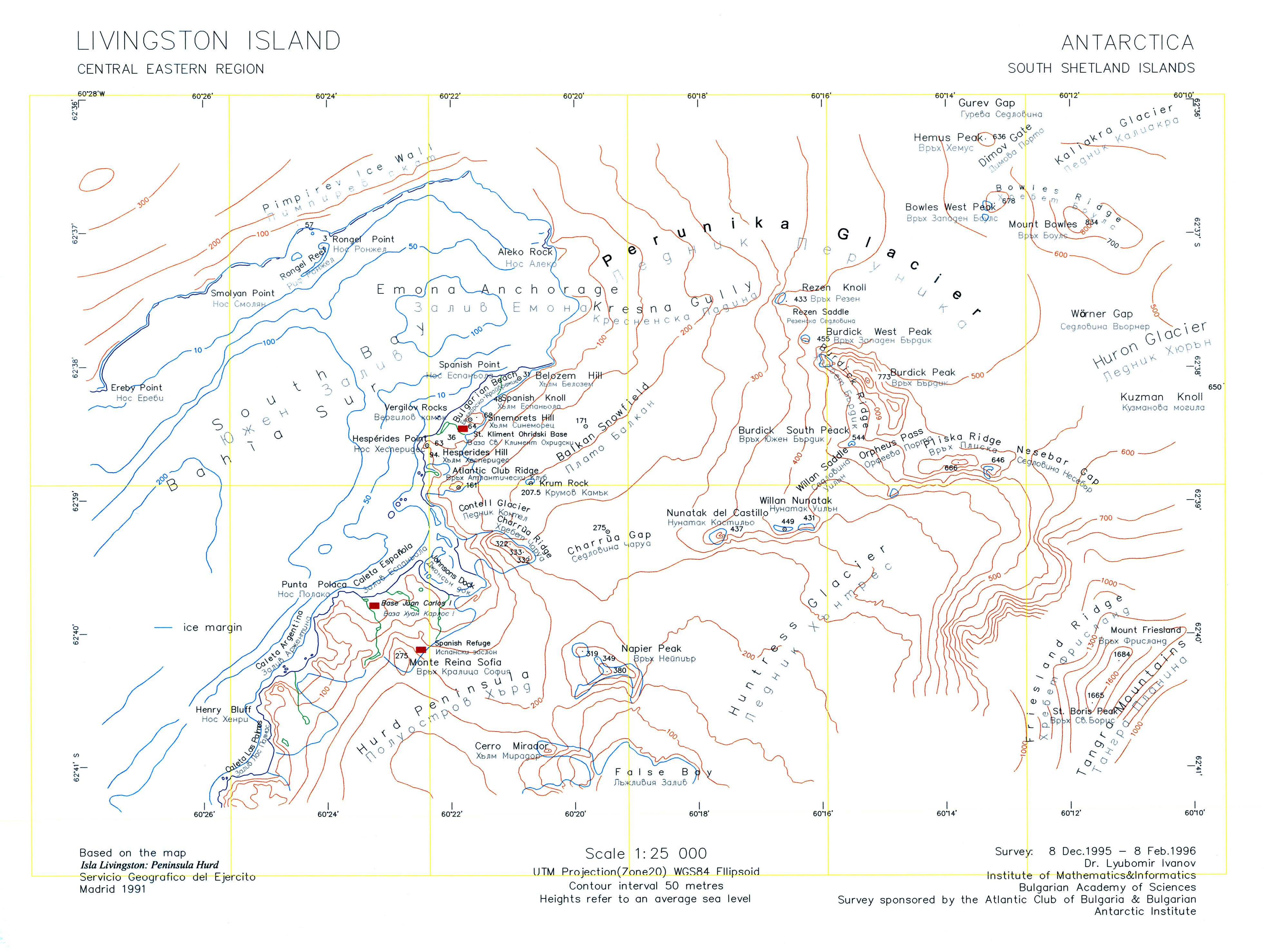
English: A version of the original 1996 map "L.L. Ivanov. Livingston Island: Central-Eastern Region. Scale 1:25000 topographic map. Sofia: Antarctic Place-names Commission of Bulgaria, 1996." uploaded by the author of that map who is also the CEO of the Antarctic Place-names Commission. |
| التاريخ | |
| المصدر | عمل شخصي |
| المؤلف | Apcbg |
| إصدارات أخرى | File:Central-Eastern-Livingston-Map-1996.png |
ترخيص
أنا، صاحب حقوق التأليف والنشر لهذا العمل، أنشر هذا العمل تحت الرخص التالية:
هذا الملفُّ مُرخَّص بموجب رخصة المشاع الإبداعي نسبة المُصنَّف إِلى مُؤَلِّفه - المشاركة بالمثل 3.0 العامة
- يحقُّ لك:
- مشاركة العمل – نسخ العمل وتوزيعه وبثُّه
- إعادة إنتاج العمل – تعديل العمل
- حسب الشروط التالية:
- نسب العمل إلى مُؤَلِّفه – يلزم نسب العمل إلى مُؤَلِّفه بشكل مناسب وتوفير رابط للرخصة وتحديد ما إذا أجريت تغييرات. بالإمكان القيام بذلك بأية طريقة معقولة، ولكن ليس بأية طريقة تشير إلى أن المرخِّص يوافقك على الاستعمال.
- الإلزام بترخيص المُشتقات بالمثل – إذا أعدت إنتاج المواد أو غيرت فيها، فيلزم أن تنشر مساهماتك المُشتقَّة عن الأصل تحت ترخيص الأصل نفسه أو تحت ترخيص مُتوافِقٍ معه.

|
يسمح نسخ وتوزيع و/أو تعديل هذه الوثيقة تحت شروط رخصة جنو للوثائق الحرة، الإصدار 1.2 أو أي إصدار لاحق تنشره مؤسسة البرمجيات الحرة؛ دون أقسام ثابتة ودون نصوص أغلفة أمامية ودون نصوص أغلفة خلفية. نسخة من الرخصة تم تضمينها في القسم المسمى GNU Free Documentation License. |
لك أن تختار الرخصة التي تناسبك.
تاريخ الملف
اضغط على زمن/تاريخ لرؤية الملف كما بدا في هذا الزمن.
| زمن/تاريخ | صورة مصغرة | الأبعاد | مستخدم | تعليق | |
|---|---|---|---|---|---|
| حالي | 10:45، 27 يوليو 2010 | | 3٬928 × 2٬952 (3٫08 ميجابايت) | Apcbg | Minor fixes. |
| 08:47، 27 يوليو 2010 |  | 3٬928 × 2٬952 (33٫23 ميجابايت) | Apcbg | {{Information |Description={{en|1=A version of the original 1996 map ''L.L. Ivanov. Livingston Island: Central-Eastern Region. Scale 1:25000 topographic map. Sofia: Antarctic Place-names Commission of Bulgaria, 1996.'' uploaded by the author of that map. |
استخدام الملف
الصفحة التالية تستخدم هذا الملف:
الاستخدام العالمي للملف
الويكيات الأخرى التالية تستخدم هذا الملف:
- الاستخدام في bg.wikipedia.org
- الاستخدام في en.wikipedia.org
- Aleko Point
- Atlantic Club Ridge
- Bowles West Peak
- Bulgarian Beach
- Charrúa Gap
- Dimov Gate
- Emona Anchorage
- Gurev Gap
- Hesperides Hill
- Kresna Gully
- Krum Rock
- Rezen Knoll
- Rezen Saddle
- Rongel Point
- Rongel Reef
- Sea Lion Glacier
- Sea Lion Tarn
- Sinemorets Hill
- Smolyan Point
- Spanish Knoll
- Spanish Point (Antarctica)
- St. Boris Peak
- Vergilov Rocks
- Willan Saddle
- Balkan Snowfield
- Belozem Hill
- Mount Friesland
- Willan Nunatak
- Contell Glacier
- Pimpirev Ice Wall
- الاستخدام في he.wikipedia.org
- الاستخدام في it.wikipedia.org
- الاستخدام في nl.wikipedia.org
- الاستخدام في pt.wikipedia.org
اعرض المزيد من الاستخدام العام لهذا الملف.