ملف:CairoIL from space annotated.jpg
الملف الأصلي (1٬000 × 750 بكسل حجم الملف: 583 كيلوبايت، نوع MIME: image/jpeg)

ملخص

الوصف

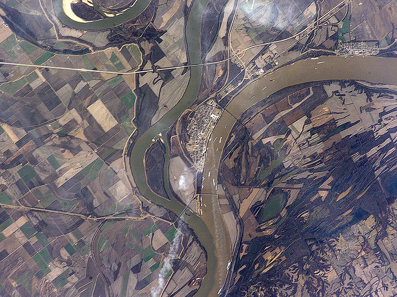
Astronaut photo of the confluence of the Mississippi and Ohio Rivers at Cairo, Illinois.


International Space Station InsigniaISS Crew Earth Observations: ISS012-E-15035International Space Station emblem
Identification
Mission ISS012 (Expedition 12)
Roll E
Frame 15035
Country or Geographic Name USA-ILLINOIS
Features CAIRO, MISSISSIPPI R., OHIO R.
Center Point Latitude 37.0° N
Center Point Longitude -89.2° E
Camera
Camera Tilt 17°
Camera Focal Length 400 mm
Camera Kodak DCS760C Electronic Still Camera
Film 3060 x 2036 pixel CCD, RGBG array.
Quality
Percentage of Cloud Cover 0-10%
Nadir What is Nadir?
Date 2006-01-12
Time 18:38:03
Nadir Point Latitude 37.2° N
Nadir Point Longitude -88.3° E
Nadir to Photo Center Direction West
Sun Azimuth 190°
Spacecraft Altitude 185 nautical miles (343 km)
Sun Elevation Angle 31°
Orbit Number 867
Original image caption
The Ohio River becomes a tributary of the Mississippi River directly south of Cairo, Illinois, a small city on the spit of land where the rivers converge (at center of this astronaut photograph). Brown, sediment-laden water flowing generally northeast to south from the Ohio River is distinct from the green and relatively sediment-poor water of the Mississippi River (flowing northwest to south). The color of the rivers in this image is reversed from the usual condition of a green Ohio and a brown Mississippi. This suggests that the very high rainfall in December 2005 over the Appalachians and the northeastern United States has led to greater-than-normal amounts of sediment in the rivers and streams of the Ohio River watershed. The distinct boundary between the two river’s waters indicates that little to no mixing occurs even 5-6 kilometers (3-4 miles) downstream.


Cairo became a prosperous port following the Civil War due to increased riverboat and railroad commerce. Small features visible in the image on the Ohio are river barges, which indicate the continued importance of Cairo as a transport hub. Flooding of the Ohio and Mississippi Rivers presents a continual danger to the city; this danger is lessened by the Birds Point-New Madrid Floodway that begins directly to the south of the river confluence. During major flood events, the floodway lessens flood stages upstream (such as at Cairo) and adjacent to the floodway. Part of the extensive levee system associated with flood control of the Mississippi River is visible in the image. Barlow Bottoms (image right), located in adjacent Kentucky, is a wetland bird-watching location that is replenished by periodic floods and releases of Ohio River water.

التاريخ
المصدر http://earthobservatory.nasa.gov/Newsroom/NewImages/images.php3?img_id=17177
المؤلف ISS Crew Earth Observations experiment and the Image Science & Analysis Group, Johnson Space Center, NASA
الترخيص
(إعادة استخدام هذا الملف)
US government, public domain

ترخيص

Public domain
يقع هذا الملفُّ في النِّطاق العامِّ في الولايات المُتحدة لأنَّه أُنشِئ مِن قبل مُختبر علوم الصُّور وتحليلها في مركز جُونسُون للفضاء التَّابِع لوَكالة الفضاء الأَمريكيَّة. تنصُّ سياسة حقوق التَّأليف والنَّشر لوَكالة الفضاء الأَمريكيَّة على أنَّ "المواد الَّتي تُنتجها الوَكالة غير مَحميَّةٍ بحقوق التَّأليف والنَّشر ما لم يُذكر خلاف ذلك". انظر (دليل استعمال الوسائِط الخاصِّ بالوَكالة أو شروط استعمال الصُّور الضُّوئِيَّة التي التقطها روَّاد الفضاء). مَصدَر الصُّورة: ISS012-E-15035.

العربيَّة | Deutsch | English | español | français | italiano | kurdî | македонски | മലയാളം | português | sicilianu | +/−

الشروح
InfoField
هذه الصورة مشروحة: أظهر الشروح في كومنز

الشروحات

أضف شرحاً من سطر واحد لما يُمثِّله هذا الملف

العناصر المصورة في هذا الملف

يُصوِّر

١٢ يناير 2006

٥٩٧٬٠٠٦ بايت

٧٥٠ بكسل

١٬٠٠٠ بكسل

تاريخ الملف

اضغط على زمن/تاريخ لرؤية الملف كما بدا في هذا الزمن.

زمن/تاريخصورة مصغرةالأبعادمستخدمتعليق
حالي17:54، 9 سبتمبر 2010تصغير للنسخة بتاريخ 17:54، 9 سبتمبر 20101٬000 × 750 (583 كيلوبايت)Holly Chengoriginal photo
21:08، 26 أبريل 2006تصغير للنسخة بتاريخ 21:08، 26 أبريل 2006540 × 405 (85 كيلوبايت)Holly Cheng{{Information | Description=Annotated image of the confluence of the Mississippi and Ohio Rivers at Cairo, Illinois. | Source=http://earthobservatory.nasa.gov/Newsroom/NewImages/images.php3?img_id=17177 | Date=January 12, 2006 |

الصفحة التالية تستخدم هذا الملف:

الاستخدام العالمي للملف

الويكيات الأخرى التالية تستخدم هذا الملف:

اعرض المزيد من الاستخدام العام لهذا الملف.

بيانات وصفية