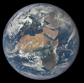
ملف:Africa and Europe from a Million Miles Away.png

حجم هذه المعاينة: 604 × 600 بكسل. الأبعاد الأخرى: 242 × 240 بكسل | 483 × 480 بكسل | 773 × 768 بكسل | 1٬031 × 1٬024 بكسل | 1٬780 × 1٬768 بكسل.
الملف الأصلي (1٬780 × 1٬768 بكسل حجم الملف: 3٫68 ميجابايت، نوع MIME: image/png)
| هذه صورة مختارة، وهذا يعني أن مجتمع ويكيبديا العربية اتفق على تصنيفها واحدة من أفضل الصور في ويكيبيديا العربية، وتضيف شيئاً هامّاً إلى مقالها. إذا كنت تملك صورة أخرى ذات جودة مشابهة، فلا تتردد في رفعها مستخدماً ترخيصاً حرّاً مناسباً، وإضافتها إلى مقال مناسب، ومن ثم ترشيحها. |
تاريخ الملف
اضغط على زمن/تاريخ لرؤية الملف كما بدا في هذا الزمن.
| زمن/تاريخ | صورة مصغرة | الأبعاد | مستخدم | تعليق | |
|---|---|---|---|---|---|
| حالي | 13:09، 9 أغسطس 2015 |  | 1٬780 × 1٬768 (3٫68 ميجابايت) | JorisvS | crop; there was too much black |
| 11:44، 8 أغسطس 2015 |  | 2٬048 × 2٬048 (2٫98 ميجابايت) | ArionStar | Tight crop | |
| 02:56، 31 يوليو 2015 |  | 1٬700 × 1٬700 (3٫67 ميجابايت) | PhilipTerryGraham | Crop | |
| 17:30، 29 يوليو 2015 |  | 2٬048 × 2٬048 (2٫98 ميجابايت) | Originalwana | {{Information |Description ={{en|1=Africa is front and center in this image of Earth taken by a NASA camera on the Deep Space Climate Observatory (DSCOVR) satellite. The image, taken July 6 from a vantage point one million miles from Earth, was one... |
استخدام الملف
ال13 صفحة التالية تستخدم هذا الملف:
- إفريقيا
- جغرافيا إفريقيا
- كوكب
- ويكيبيديا:ترشيحات الصور المختارة/إفريقيا وأوروبا
- ويكيبيديا:صور مختارة/الفضاء والكون/نظرة إلى الخلف
- ويكيبيديا:صورة اليوم المختارة/ديسمبر 2022
- ويكيبيديا:صورة اليوم المختارة/سبتمبر 2018
- ويكيبيديا:صورة اليوم المختارة/فبراير 2020
- قالب:صورة اليوم المختارة/2018-09-07
- قالب:صورة اليوم المختارة/2020-02-29
- قالب:صورة اليوم المختارة/2022-12-31
- بوابة:علم الفلك/صورة مختارة
- بوابة:علم الفلك/صورة مختارة/64
الاستخدام العالمي للملف
الويكيات الأخرى التالية تستخدم هذا الملف:
- الاستخدام في af.wikipedia.org
- الاستخدام في as.wikipedia.org
- الاستخدام في bcl.wikipedia.org
- الاستخدام في be-tarask.wikipedia.org
- الاستخدام في blk.wikipedia.org
- الاستخدام في ckb.wikipedia.org
- الاستخدام في crh.wikipedia.org
- الاستخدام في cv.wikipedia.org
- الاستخدام في de.wiktionary.org
- الاستخدام في el.wikipedia.org
- الاستخدام في el.wiktionary.org
- الاستخدام في en.wikipedia.org
- List of Solar System objects by size
- Wikipedia:Userboxes/Seasonal
- User:Kwamikagami/sandbox
- Talk:Earth/Archive 14
- User:Kazkaskazkasako/Books/Physical sciences
- User:Rfassbind/sandbox/Leadimage compilations
- Talk:Earth/Archive 15
- User:VGrigas (WMF)/Quality Media
- User:Jmaxx37
- Wikipedia:Wikipedia Signpost/2018-10-28/Gallery
- Wikipedia:Wikipedia Signpost/Single/2018-10-28
- User:Applekle/sandbox
- User:Double sharp/Largest Solar System objects
- User:Maria DDias/TWA/Earth/2
- User:Jmaxx37/Userboxes
- User:Jmaxx37/Userboxes/Fav-holiday Earth Day
- Wikipedia talk:WikiProject Userboxes/New Userboxes/Archive 38
- User:Roger Capybara6
- User:KeroseneLover100/sandbox/sandbox
- الاستخدام في en.wikiquote.org
- الاستخدام في en.wikiversity.org
- الاستخدام في es.wikipedia.org
- الاستخدام في eu.wikipedia.org
- الاستخدام في fr.wikipedia.org
- الاستخدام في ha.wikipedia.org
- الاستخدام في hu.wikipedia.org
- الاستخدام في incubator.wikimedia.org
اعرض المزيد من الاستخدام العام لهذا الملف.


